


Refuge du pigeonnier / lac bleu

mthomas30
User
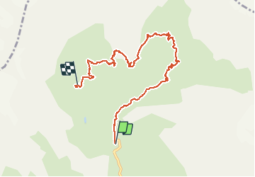

Length
9.1 km

Max alt
2463 m

Uphill gradient
1038 m
Km-Effort
21 km

Min alt
1633 m

Downhill gradient
498 m
Boucle
No
Creation date :
2020-08-06 06:25:02.32
Updated on :
2020-08-23 20:04:48.629
5h34
Difficulty : Medium

FREE GPS app for hiking
 SityTrail
IGN / Geographical institutes
SityTrail Plus
The world is yours!
About
Trail Walking of 9.1 km to be discovered at Provence-Alpes-Côte d'Azur, Hautes-Alpes, La Chapelle-en-Valgaudémar. This trail is proposed by mthomas30.
Description
Bivouca au lac.
Positioning
Country:
France
Region :
Provence-Alpes-Côte d'Azur
Department/Province :
Hautes-Alpes
Municipality :
La Chapelle-en-Valgaudémar
Location:
Unknown
Start:(Dec)
Start:(UTM)
285130 ; 4968870 (32T) N.
Comments